

Modelling agricultural land changes: mobilise historical sources to gather past knowledge with geographic evidence
The agricultural land changes we observe today are the direct result of a combination of social, economic, and environmental factors, varying at a range of spatial and temporal scales. Thus, many land-change models based on geographic theory and reconstructions of past developments have been applied as tools to extrapolate past agricultural land changes and predict future changes. Modelling agricultural land changes using land‐change models provides a more spatially detailed and plausible assessment of agricultural land systems, advancing our understanding of their long-term sustainability and global implications.
In a broad sense, the emergence of land-change modelling approaches has been driven by increased computing power, the exponential development of geographic information systems (GIS), particularly the geocomputation discipline and system theories (such as complexity, self-organising, and non-linear theories), data collection techniques and available database software. Currently, models integrated or interfacing with artificial intelligence (AI), in particular machine learning, and linking to disciplines such as computing and mathematics are popular.
The value of spatial data
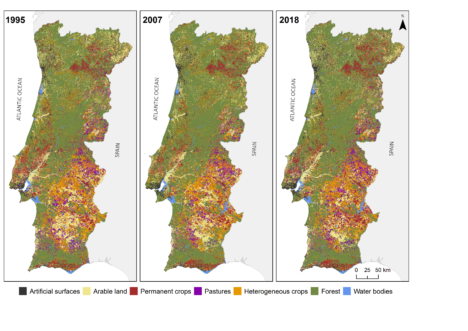
For this reason, data availability and timely and accurate spatial data are crucial. Advances in remote sensing technology and the increasing availability of open georeferenced data collected and produced by government agencies, social media, and mobile devices have contributed to a plethora of spatial data. Remotely sensed data providing large-scale high-resolution land-use data are the most common data used in land-change modelling. For example, Landsat images at 30 m spatial resolution are widely used for multi-temporal mapping, quantification, and assessing land changes for their high temporal frequency, regular coverage (almost 40 years of data records), and free availability. In addition, thematic cartography produced with regularity and reliability by governmental institutions at the country level is a valuable resource providing insights. An example of a national dataset is the official Portuguese Land Cover Map (COS) produced by the Portuguese General Directorate for Territorial Development (DGT), which is freely available for 1995, 2007, 2010, 2015, and 2018 (Figure 1).
The potential of historical sources
Alternatively, historical datasets relying on local and regional statistics/records (census data, historical data on climate), old analogical documents (maps, cadastres, registers), have been gathered and widely used as data sources (Figure 2). In particular, most historical sources have some geographic information contained. When did the phenomenon change place, where did the phenomenon occur, and what is the spatial extent of the phenomenon? All of these are questions that historians and geographers would answer in order to complement and structure new knowledge.
Both fields are in fact divided between space and time, and while historians can’t ignore space geographers hardly overlook time. The Historical GIS (HGIS) field of research originated in the Social and Human Sciences when these two elements, time and place, were brought together to verify historical explanation with empirical geographical evidence. HGIS is an interdisciplinary discipline that focuses on empirical-spatial research themes using a local-scale geospatial approach and GIS as an analytical tool to address historical issues. Indeed, GIS technology has played a significant role in the reconstruction of archive maps by extracting, analysing, and comparing previous information with new information, inspiring new scenarios of understanding by searching in space for the temporal evolution of historical-geographical events through the construction of visual arguments and textual typologies using maps and diagrams representing spatial processes. Because historical data is available in a variety of formats, including analogical and tabular data, it can be turned into digital maps. For example, the Great Britain Historical GIS made a geographical information system containing historical information from Britain available, based on documentary sources such as statistics, maps, and historical documents.
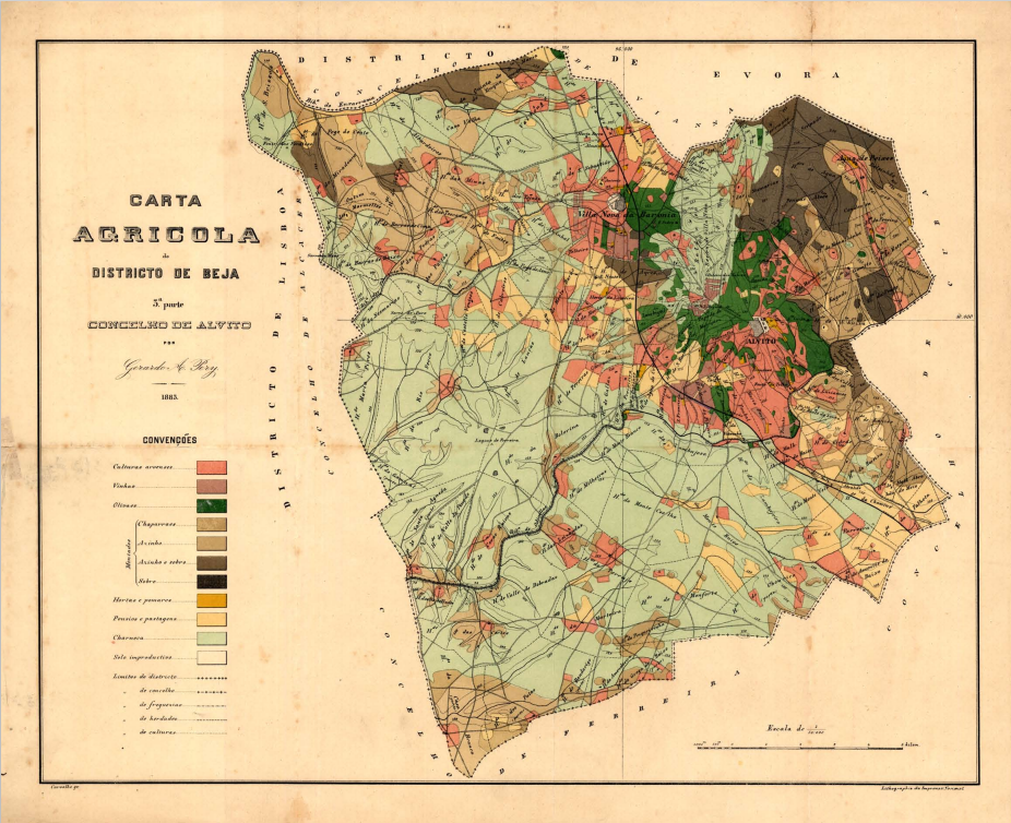
Figure 2. Old analogical map of agricultural areas in the Beja district, Portugal (1883).
Source: Ministry of Public Works, Commerce and Industry, 1883.
On a more general note, covering the past using long-term perspectives (crossing different years, decades, or centuries) offers historical viewpoints that can provide spatially and temporally accurate information that contributes to effective land management and promotes proper, efficient, and rational agricultural land use. For this reason, the ability to map, monitor, quantify, and model agricultural land dynamics are practices that assist conscious and thrifty management of this natural resource, resulting in effective environmental planning and informed policy decisions for the future.
Cláudia M. Viana is a Geospatial Information Scientist and Geographer. Ph.D. in Geography (2022) with a grant from the Portuguese Foundation for Science and Technology. Master in Geographic Information System (2014) and a Degree in Geography (2012). She is currently an Associate Researcher at Centre for Geographical Studies at the University of Lisbon. She has authored and co-authored more than 10 scientific papers with over 160 citations. Her research areas and activities lie within modelling the spatiotemporal changes of agricultural land use, as well as the spatial distribution over time of agricultural production. Along with university teaching, she has integrated or collaborated on multiple national and international research projects.
0 Comments